The Climate of
Algeria
.jpg) Martyrs' Memorial, Algiers
Martyrs' Memorial, Algiers
.jpg&oldid=611434020)
Climate Map
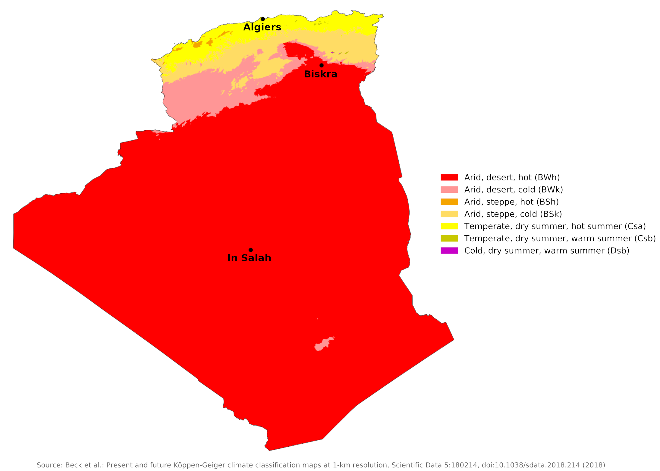 Climate map of Algeria
What is the climate of Algeria like?
Algeria is a North African country on the Mediterranean Sea; it is about four times the size of France. Algeria is bounded on the east by Tunisia and Libya, on the south by Niger, and Mali, on the west by Mauritania, Western Sahara, and Morocco. About one sixth of the country, consisting of the Mediterranean coasts and the northern mountains, has a typical Mediterranean climate with winter precipitation. The remainder of the country south of the Sahara Atlas Mountains is almost rain-free and is part of the great Sahara Desert.
Along the coast, the weather is very mild, rarely freezing even in winter. The coldest month is January and the hottest is August. The average annual temperature on the coastal plains is 19°C (66°F). It rains frequently from November to March, and rain is not uncommon in other months either, with the exception of June, July, August and September, which are very hot and rainless. Algiers is representative of the coast.
Northern Algeria has a varied relief with two moderately high mountain ranges: the Tell Atlas and the Sahara Atlas, separated by a region of high plateaux and internal basins, the Plateau. The climate and weather here vary locally depending on the altitude. From May to September the weather here is generally calm and hot with almost constant sunshine. During the rest of the year it is more changeable, alternating from warm sunny days and cool nights to choppy periods of rain and clouds.
In eastern Algeria, the average temperatures are somewhat lower, and on the steppes of the High Plateaus winter temperatures hover only a few degrees above freezing. A prominent feature of the climate in this region is the sirocco, a dusty, choking south wind blowing off the desert, sometimes at gale force. This wind also occasionally reaches into the coastal Tell.
Precipitation is heaviest and most reliable along the Mediterranean coast and in the higher parts of the Tell Atlas, where it varies between 400 millimeters (16 inches) and 800 millimeters (32 inches) per year. Precipitation is heaviest in the northern part of eastern Algeria, where it reaches as much as 1,000 millimeters (40 inches) in some years.
Prevailing winds that are easterly and northeasterly in summer change to westerly and northerly in winter and carry with them a general increase in precipitation from September to December, a decrease in the late winter and spring months, and a near absence of rainfall during the summer months. Most rain falls between September and May, with the heaviest and most reliable rains occurring from November to March. Above 1,000 meters (3,000 feet) precipitation often falls as snow and at the highest elevations winter is often severe and snow can lie on the ground for several weeks.
| Climate data for Algiers (1976–2005) | |||||||||||||
|---|---|---|---|---|---|---|---|---|---|---|---|---|---|
| Month | Jan | Feb | Mar | Apr | May | Jun | Jul | Aug | Sep | Oct | Nov | Dec | Year |
| Average high °C (°F) | 16.7 (62.1) | 17.4 (63.3) | 19.3 (66.7) | 20.9 (69.6) | 23.9 (75.0) | 28.2 (82.8) | 31.2 (88.2) | 32.2 (90.0) | 29.6 (85.3) | 25.9 (78.6) | 20.8 (69.4) | 17.9 (64.2) | 23.7 (74.7) |
| Daily mean °C (°F) | 11.1 (52.0) | 11.7 (53.1) | 13.2 (55.8) | 14.9 (58.8) | 18.1 (64.6) | 22.2 (72.0) | 25.1 (77.2) | 26.0 (78.8) | 23.6 (74.5) | 20.1 (68.2) | 15.3 (59.5) | 12.6 (54.7) | 17.8 (64.0) |
| Average low °C (°F) | 5.5 (41.9) | 5.9 (42.6) | 7.1 (44.8) | 8.8 (47.8) | 12.3 (54.1) | 16.1 (61.0) | 18.9 (66.0) | 19.8 (67.6) | 17.6 (63.7) | 14.2 (57.6) | 9.8 (49.6) | 7.2 (45.0) | 11.9 (53.4) |
| Average precipitation mm (inches) | 81.4 (3.20) | 72.7 (2.86) | 55.0 (2.17) | 58.4 (2.30) | 41.9 (1.65) | 8.5 (0.33) | 4.5 (0.18) | 8.2 (0.32) | 28.3 (1.11) | 58.8 (2.31) | 89.6 (3.53) | 91.0 (3.58) | 598.3 (23.56) |
| Source: World Meteorological Organization | |||||||||||||
Inland, on the plateau and in the Sahara Atlas, the climate is more extreme continental—the temperature varies from one extreme to the other and it rarely rains. In winter there is frost and snow and the nights can get very cold after fairly warm days. The summer heat often reaches Saharan levels, but is more bearable due to the low humidity. Rainfall is relatively low over much of the area, with a tendency towards a double maximum in autumn and spring. A narrow belt of steppes, similar to that in southern Tunisia, extends immediately south of the Sahara Atlas. Winter has a distinct rainy season, but rainfall is scant and unreliable. Biskra is typical of this area on the edge of the Sahara.
| Climate data for Biskra (1976–2005) | |||||||||||||
|---|---|---|---|---|---|---|---|---|---|---|---|---|---|
| Month | Jan | Feb | Mar | Apr | May | Jun | Jul | Aug | Sep | Oct | Nov | Dec | Year |
| Average high °C (°F) | 16.9 (62.4) | 19.2 (66.6) | 23.4 (74.1) | 26.1 (79.0) | 31.3 (88.3) | 37.6 (99.7) | 40.9 (105.6) | 40.4 (104.7) | 34.7 (94.5) | 28.2 (82.8) | 22.1 (71.8) | 18.5 (65.3) | 28.2 (82.8) |
| Daily mean °C (°F) | 11.5 (52.7) | 13.6 (56.5) | 17.6 (63.7) | 21.3 (70.3) | 25.8 (78.4) | 32.5 (90.5) | 34.5 (94.1) | 34.2 (93.6) | 30.0 (86.0) | 23.2 (73.8) | 16.8 (62.2) | 12.9 (55.2) | 22.8 (73.0) |
| Average low °C (°F) | 6.1 (43.0) | 7.9 (46.2) | 11.7 (53.1) | 16.5 (61.7) | 20.2 (68.4) | 26.6 (79.9) | 28.1 (82.6) | 27.9 (82.2) | 25.3 (77.5) | 18.1 (64.6) | 11.4 (52.5) | 7.2 (45.0) | 17.4 (63.3) |
| Average precipitation mm (inches) | 17.4 (0.69) | 10.2 (0.40) | 13.6 (0.54) | 13.1 (0.52) | 11.1 (0.44) | 5.1 (0.20) | 1.7 (0.07) | 5.7 (0.22) | 10.4 (0.41) | 11.3 (0.44) | 20.1 (0.79) | 9.1 (0.36) | 128.8 (5.07) |
| Source: World Meteorological Organization | |||||||||||||
The Sahara desert region in Algeria is hot and practically rainless. Even in winter, midday desert temperatures can be very hot. After sunset, however, the clear, dry air permits rapid loss of heat, and the nights are cool to chilly. Enormous daily ranges in temperature are recorded. Summer temperatures are consistently high, but nighttime temperatures drop low enough to be quite bearable. Winter nights in the Sahara can be chilly and frost is not unknown, but the days are warm and sunny.
In the desert it can occasionally rain in any month, but amounts are so small and unreliable that averages become meaningless. In the far south of Algeria, sporadic rains are more likely in the period from June to September, because the intertropical rain belt, which affects West Africa at this time, occasionally extends so far north. In southeastern Algeria, the great mass of the Hoggar Mountains, which rise to 2,900 meters (9,500 feet), receives a little more rain, which can fall at any time of the year. The oasis city of In Salah in the center of the Sahara is representative of this vast desert region.
| Climate data for In Salah (2000–2015) | |||||||||||||
|---|---|---|---|---|---|---|---|---|---|---|---|---|---|
| Month | Jan | Feb | Mar | Apr | May | Jun | Jul | Aug | Sep | Oct | Nov | Dec | Year |
| Average high °C (°F) | 22.3 (72.1) | 25.1 (77.2) | 30.5 (86.9) | 35.2 (95.4) | 39.6 (103.3) | 43.8 (110.8) | 46.4 (115.5) | 45.2 (113.4) | 41.9 (107.4) | 36.2 (97.2) | 28.0 (82.4) | 23.2 (73.8) | 34.64 (94.35) |
| Daily mean °C (°F) | 14.7 (58.5) | 17.2 (63.0) | 22.4 (72.3) | 26.6 (79.9) | 31.4 (88.5) | 35.7 (96.3) | 38.5 (101.3) | 37.6 (99.7) | 34.3 (93.7) | 28.8 (83.8) | 20.6 (69.1) | 16.0 (60.8) | 26.84 (80.31) |
| Average low °C (°F) | 7.3 (45.1) | 9.6 (49.3) | 14.1 (57.4) | 18.2 (64.8) | 23.2 (73.8) | 27.5 (81.5) | 30.7 (87.3) | 30.1 (86.2) | 26.7 (80.1) | 21.3 (70.3) | 13.2 (55.8) | 8.8 (47.8) | 19.06 (66.31) |
| Average precipitation mm (inches) | 3.7 (0.15) | 3.5 (0.14) | 1.2 (0.05) | 1.6 (0.06) | 0.5 (0.02) | 0.1 (0.00) | 0.0 (0.0) | 0.5 (0.02) | 0.2 (0.01) | 1.2 (0.05) | 0.5 (0.02) | 2.7 (0.11) | 15.7 (0.63) |
| Source: Arab Meteorology Book | |||||||||||||
Algeria has a very sunny climate. In the north, the daily sunshine duration is five to six hours in winter and eleven to twelve hours in summer. In the Sahara they approach the maximum possible duration: nine to ten in winter and twelve to thirteen in summer.
In the Sahara, strong winds occasionally kick up dust and sand, which can be both dangerous and highly unpleasant. Between May and September, the sirocco, or hot desert wind, periodically sweeps across the country, impregnating the air with fine sand.
References
- E. A. Pearce, Charles Gordon Smith, (1990) The Hutchinson World Weather Guide, John Murray Press. ISBN 1859863426
- Timothy L. Gall, (ed.), (2003), Worldmark Encyclopedia of the Nations, Eleventh Edition, Thomson Gale
- Federal Research Division, Library of Congress, (1994), Algeria: a country study. Claitor's Pub. Division. ISBN 084440831X
- Hugh Chisholm, (ed.), (1911), Encyclopædia Britannica, Eleventh edition, Cambridge University Press
The Climate of
Algeria
In summary:
The northern part of Algeria has a Mediterranean climate with mild, wet winters and hot, dry summers. The plateau region has a semiarid climate, with greater contrasts between summer and winter. Temperatures vary the most in the Sahara Desert region, which has an arid climate with very high summer temperatures.
Algeria’s rainfall also differs by region. Fewer than 100 mm (4 in) of rain fall annually in the Sahara Desert, but as many as 1000 mm (40 in) may fall in the easternmost section of the mountainous Tell region in the north. Precipitation is heaviest between September and December, tapering off in January. Very little rainfall occurs in the summer months. Drought occurs frequently in the Saharan region.