The Climate of
Georgia
 Freedom Square, Tbilisi
Climate Map
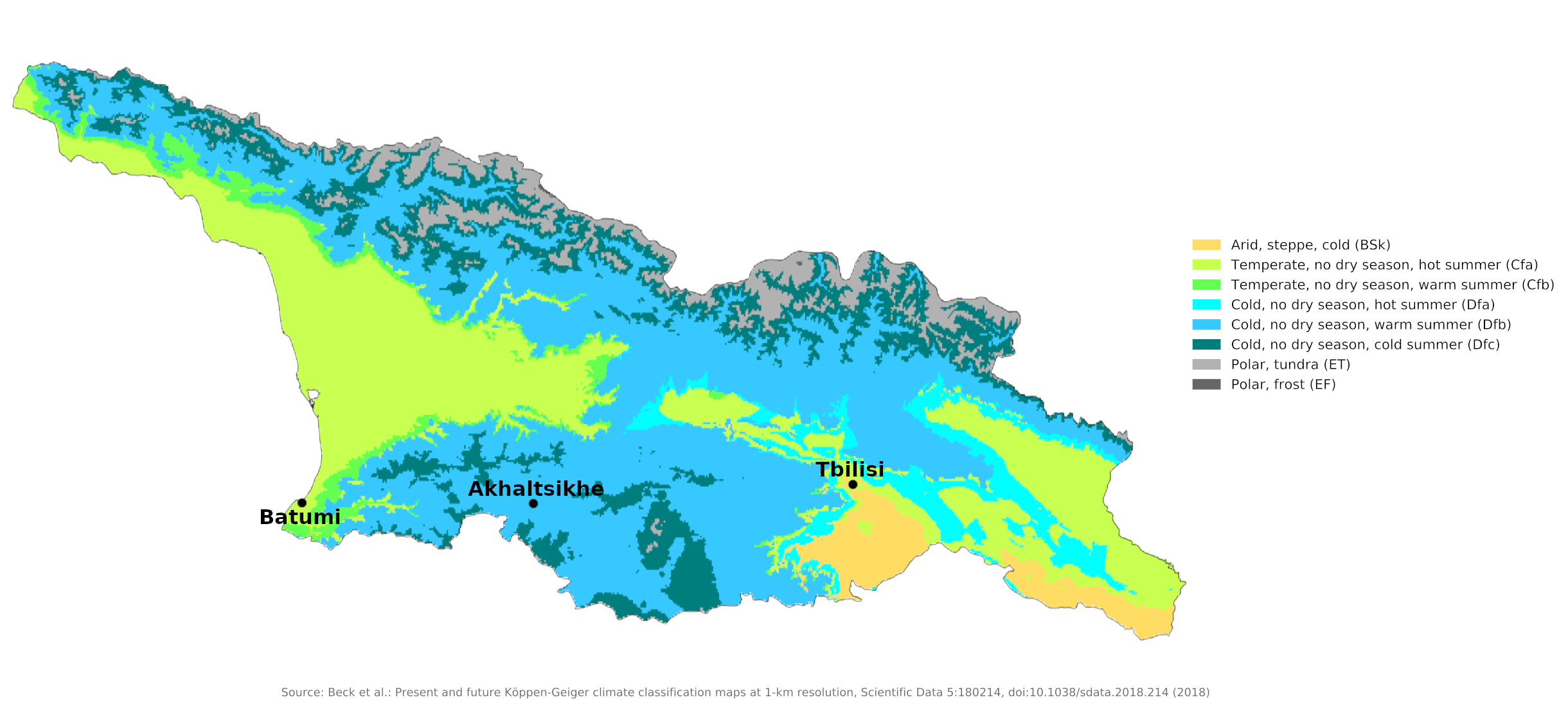 Climate map of Georgia
What is the climate of Georgia like?
Georgia is located in southwest Asia, east of the Black Sea. It borders Turkey and Armenia on the south, Azerbaijan on the southeast, and Russia on the north. On the shores of the Black Sea there are lowlands; the rest of the country is mountainous, with the Greater Caucasus to the north and the Lesser Caucasus to the south.
The Georgian climate is particularly humid, warm and pleasant on the Black Sea coast and almost tropical in summer, while winters are even warmer than in the mild southern Russian regions to the north. The Greater Caucasus to the north protects this area from really cold weather. The average summer temperature along the coast is 22°C (72°F). Even in the middle of winter, the average temperature is 5°C (41°F).
The eastern plains
The eastern plains, cut off from the sea by the Suram Mountains, have a more continental climate with hot summers and cold winters. Summer temperatures there range between 20° and 24°C (68–75°F), while in winter they range between 2° and 4°C (36–39°F). Cold spells occur and low temperatures are common in the deep, closed valleys in winter. Tbilisi in southeastern Georgia illustrates inland lowland conditions. Humidity is low, and rainfall averages 500 to 800 millimeters (20–32 inches) per year. Alpine and highland regions in the east and west, as well as a semiarid region on the Iori Plateau to the southeast, have distinct microclimates.
| Climate data for Tbilisi (1981–2010) | |||||||||||||
|---|---|---|---|---|---|---|---|---|---|---|---|---|---|
| Month | Jan | Feb | Mar | Apr | May | Jun | Jul | Aug | Sep | Oct | Nov | Dec | Year |
| Average high °C (°F) | 6.6 (43.9) | 7.6 (45.7) | 12.3 (54.1) | 18.6 (65.5) | 22.8 (73.0) | 27.7 (81.9) | 31.1 (88.0) | 30.9 (87.6) | 26.1 (79.0) | 19.4 (66.9) | 12.4 (54.3) | 7.6 (45.7) | 18.7 (65.7) |
| Daily mean °C (°F) | 1.3 (34.3) | 2.7 (36.9) | 6.8 (44.2) | 12.6 (54.7) | 17.0 (62.6) | 21.5 (70.7) | 24.5 (76.1) | 23.9 (75.0) | 19.5 (67.1) | 13.2 (55.8) | 7.7 (45.9) | 3.3 (37.9) | 12.8 (55.0) |
| Average low °C (°F) | −1.0 (30.2) | −0.7 (30.7) | 2.8 (37.0) | 8.0 (46.4) | 12.4 (54.3) | 16.6 (61.9) | 20.0 (68.0) | 19.7 (67.5) | 15.7 (60.3) | 10.4 (50.7) | 4.6 (40.3) | 0.4 (32.7) | 9.1 (48.4) |
| Average precipitation mm (inches) | 20.2 (0.80) | 26.5 (1.04) | 32.8 (1.29) | 56.4 (2.22) | 86.2 (3.39) | 72.1 (2.84) | 48.2 (1.90) | 43.8 (1.72) | 42.7 (1.68) | 42.7 (1.68) | 35.2 (1.39) | 25.0 (0.98) | 531.6 (20.93) |
| Source: World Meteorological Organization | |||||||||||||
The mountains
The climate gets cooler in the mountains—see the example of Akhaltsikhe which is about 1,000 meters (3,300 feet) above sea level. Precipitation in some places can be twice as heavy as in the eastern plains. In the west, the climate is sub-tropical to about 650 meters (2,100 feet); above that altitude (and to the north and east) is a band of moist and moderately warm weather, then a band of cool and wet conditions. Alpine conditions start at around 2,100 meters (6,800 feet). Above 3,600 meters (12,000 feet), the mountains are covered in snow and ice all year round.
| Climate data for Akhaltsikhe (1981–2010) | |||||||||||||
|---|---|---|---|---|---|---|---|---|---|---|---|---|---|
| Month | Jan | Feb | Mar | Apr | May | Jun | Jul | Aug | Sep | Oct | Nov | Dec | Year |
| Average high °C (°F) | 3.1 (37.6) | 5.0 (41.0) | 11.0 (51.8) | 17.6 (63.7) | 21.9 (71.4) | 25.5 (77.9) | 28.9 (84.0) | 29.4 (84.9) | 25.2 (77.4) | 18.6 (65.5) | 10.9 (51.6) | 4.8 (40.6) | 16.8 (62.2) |
| Daily mean °C (°F) | −3.1 (26.4) | −1.6 (29.1) | 3.3 (37.9) | 9.1 (48.4) | 13.4 (56.1) | 17.1 (62.8) | 20.5 (68.9) | 20.5 (68.9) | 16.1 (61.0) | 10.3 (50.5) | 3.9 (39.0) | −1.3 (29.7) | 9.0 (48.2) |
| Average low °C (°F) | −7.4 (18.7) | −6.3 (20.7) | −2.4 (27.7) | 2.6 (36.7) | 6.9 (44.4) | 10.8 (51.4) | 14.2 (57.6) | 13.7 (56.7) | 9.1 (48.4) | 4.3 (39.7) | −0.8 (30.6) | −5.4 (22.3) | 3.3 (37.9) |
| Average precipitation mm (inches) | 24.3 (0.96) | 26.7 (1.05) | 35.9 (1.41) | 49.3 (1.94) | 67.0 (2.64) | 77.7 (3.06) | 61.0 (2.40) | 49.8 (1.96) | 34.3 (1.35) | 40.5 (1.59) | 35.3 (1.39) | 26.2 (1.03) | 527.9 (20.78) |
| Source: World Meteorological Organization | |||||||||||||
The subtropical coast
The western part of the country is subtropical and humid, and several varieties of palm trees grow in these regions. The areas along the Black Sea coast and inland through the Kolkhida lowlands experience high humidity and heavy rainfall of 1,000 to 2,000 millimeters (40 to 80 in) per year. The Black Sea port of Batumi is the wettest city in Georgia, receiving 2,500 millimeters (100 inches) of rain per year. Inland, humidity is lower and rainfall averages 460 to 810 millimeters (18 to 32 inches) per year.
| Climate data for Batumi | |||||||||||||
|---|---|---|---|---|---|---|---|---|---|---|---|---|---|
| Month | Jan | Feb | Mar | Apr | May | Jun | Jul | Aug | Sep | Oct | Nov | Dec | Year |
| Average high °C (°F) | 10.3 (50.5) | 11.2 (52.2) | 12.5 (54.5) | 16.2 (61.2) | 20.1 (68.2) | 24.3 (75.7) | 26.2 (79.2) | 26.5 (79.7) | 23.5 (74.3) | 20.3 (68.5) | 15.8 (60.4) | 12.7 (54.9) | 18.3 (64.9) |
| Daily mean °C (°F) | 6.6 (43.9) | 6.7 (44.1) | 8.8 (47.8) | 12.3 (54.1) | 16.0 (60.8) | 20.2 (68.4) | 22.6 (72.7) | 23.1 (73.6) | 19.9 (67.8) | 16.4 (61.5) | 11.9 (53.4) | 9.0 (48.2) | 14.5 (58.0) |
| Average low °C (°F) | 4.1 (39.4) | 3.8 (38.8) | 5.5 (41.9) | 9.3 (48.7) | 13.1 (55.6) | 17.3 (63.1) | 19.9 (67.8) | 20.3 (68.5) | 16.9 (62.4) | 13.4 (56.1) | 9.1 (48.4) | 6.4 (43.5) | 11.6 (52.9) |
| Average precipitation mm (inches) | 238 (9.4) | 189 (7.4) | 153 (6.0) | 113 (4.4) | 108 (4.3) | 142 (5.6) | 168 (6.6) | 205 (8.1) | 262 (10.3) | 277 (10.9) | 312 (12.3) | 268 (10.6) | 2,435 (95.9) |
| Source: Climate-Data.org | |||||||||||||
References
- E. A. Pearce, Charles Gordon Smith, (1990) The Hutchinson World Weather Guide, John Murray Press. ISBN 1859863426
- Timothy L. Gall, (ed.), (2003), Worldmark Encyclopedia of the Nations, Eleventh Edition, Thomson Gale
- Federal Research Division, Library of Congress, (1995), Armenia, Azerbaijan, and Georgia: country studies. Claitor's Pub. Division. ISBN 0844408484
- Hugh Chisholm, (ed.), (1911), Encyclopædia Britannica, Eleventh edition, Cambridge University Press
The Climate of
Georgia
In summary:
Georgia’s climate along the Black Sea coast is Mediterranean. Further inland the climate is continental, with warm summers and cold winters. July’s mean temperature is 23°C (73.8°F). The mean temperature in January is -3°C (27.3°F).
The annual rainfall in Tbilisi is 530 mm (21 in) but is rather higher along the Black Sea coast.