The Climate of
Bolivia
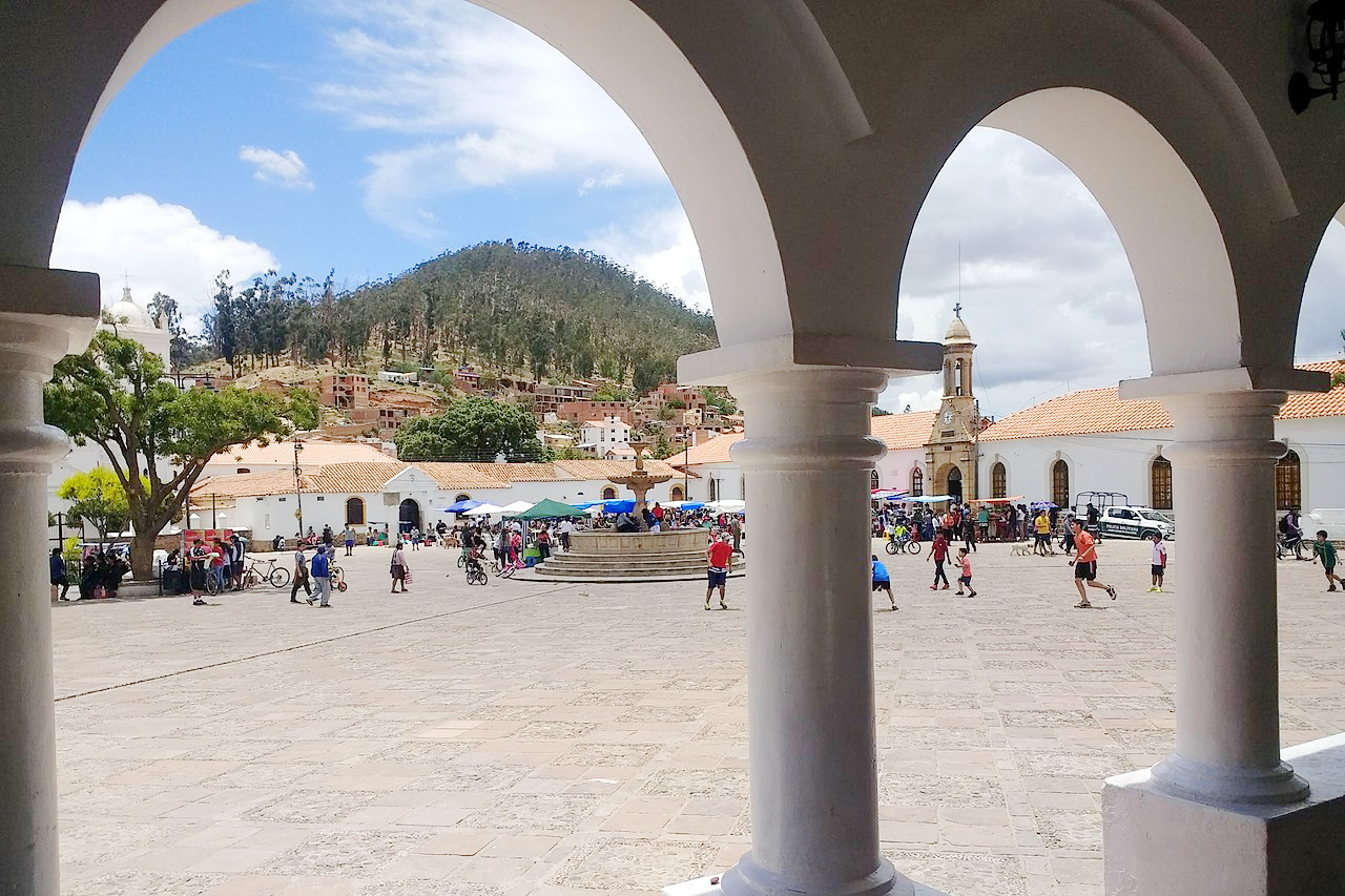 Plaza Pedro de Anzúrez in Sucre
Climate Map
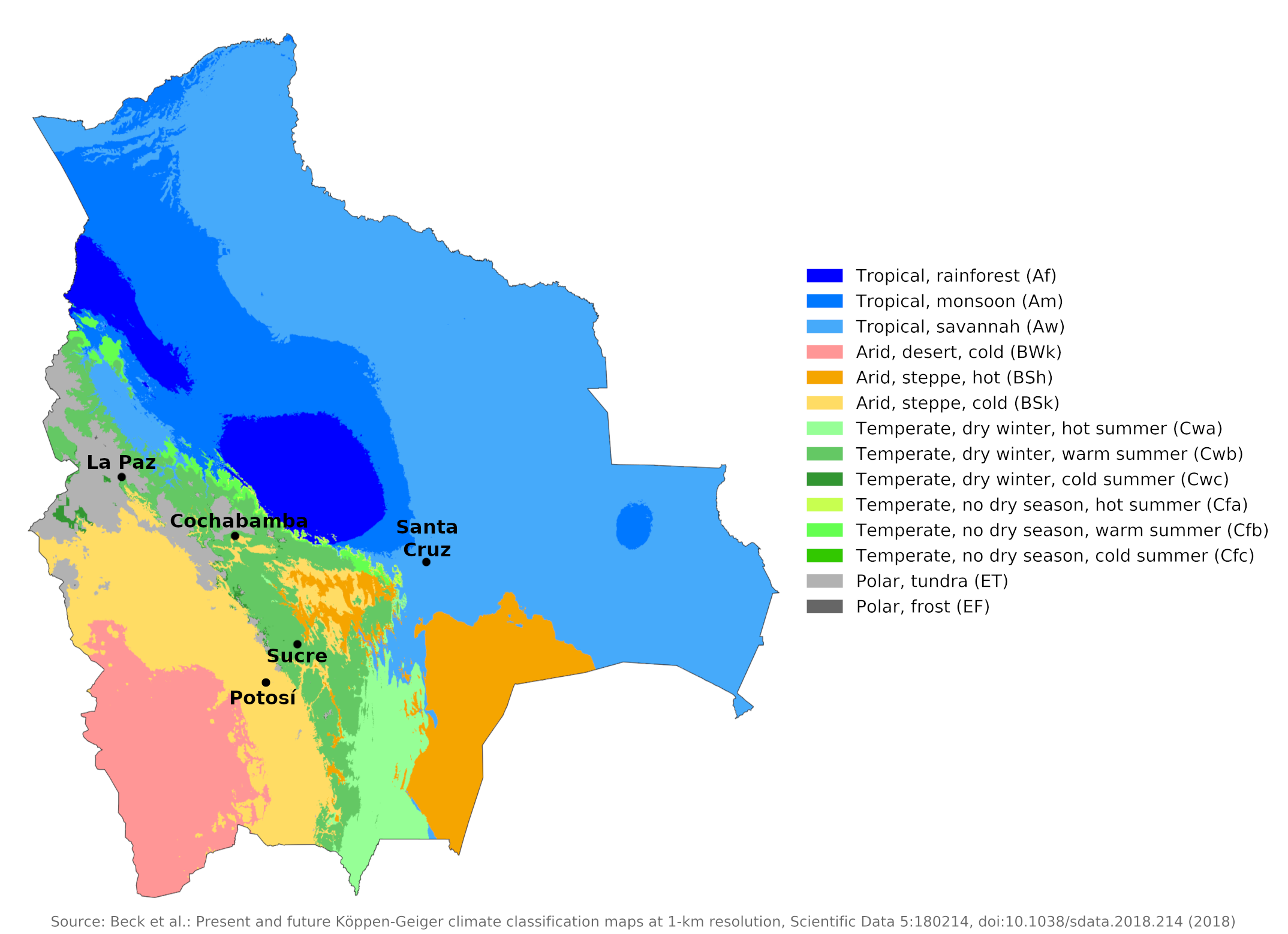 Climate map of Bolivia
What is the climate of Bolivia like?
Bolivia is a landlocked country twice the size of France or the state of Texas. It is bordered on the north by Brazil, east by Paraguay, south by Argentina, and west by Chile and Peru.
The country is divided into two physically very different regions with very different weather and climates. To the west, the great Andes mountain range, at its widest here, rises to peaks in excess of 6,000 meters (20,000 feet). Between the western and eastern reaches of the Andes, at an elevation of 3,000 to 4,000 meters (10,000 to 13,000 feet), is a vast highland plateau known as the Páramos or Altiplano. East of the Andes, the land drops steeply to the forested lowlands of the Amazon Basin on the Brazilian border and the lowlands of the Chaco region on the Paraguay border.
The trade winds give southern Bolivia a rainy and dry season similar to that in northern Argentina. Further north and east of the Cordillera Oriental, rain falls year-round, although the summer months (November to March) are usually referred to as the rainy season. On the western side of the Cordillera, which saps moisture from the prevailing easterly winds, the plateaux in the north have limited rainfall that decreases towards the south until the surface becomes absolutely barren.
The Andean Plateau
La Paz at 3,650 meters (11,975 feet) is typical of the Andean Plateau ("Altiplano") climate. An extreme tropical highland climate prevails here. Annual rainfall is low, occurring mainly between December and March, during the high sun period when there are many rainy days. Temperatures are greatly reduced by altitude, with little variation from month to month. The daily temperature fluctuations are large, so that the nights are quite cold, especially during the dry winter, or period with little sun, when frost occurs almost every night. Cold winds blow in the Altiplano; in the northern Altiplano, on the other hand, the climate is moderated by Lake Titicaca.
The region between 3,350 and 3,800 meters (11,000 and 12,500 feet) includes the great central plateau of Bolivia. It only has two seasons, a cold summer or autumn and winter. The air is cold and dry. The mean temperature is 12°C (54°F). From 3,800 meters (12,500 ft) to the snow line (about 5,300 meters or 17,500 ft), the climate becomes inhospitable, inhabited only by shepherds and miners. Above lies the region of perpetual snow, an arctic zone within the tropics.
Short and heavy rainstorms sometimes sweep across the northern plateau, but these are infrequent and only occur during a short season. Electrical wind storms are common at these altitudes.
In some parts of this region, annual rainfall is as little as 250 millimeters (10 inches). This is especially true of the western mountains and valleys (see the climate of Potosí at 4,090 meters or 13,420 feet). Consequently, the permanent snowline can be as high as 6,000 meters (20,000 feet). Because of the high altitude of this region, barometric pressure at 3,000 meters (10,000 ft) is only about two-thirds that at sea level, and at 5,200 meters (17,000 ft) only about half. This reduced pressure causes problems for visitors, who may suffer from altitude sickness, locally called soroche, upon arrival. For a fit person, acclimatization takes anywhere from a few days to about a week; but the area is not recommended for those suffering from weak hearts or lung ailments.
Sunshine duration ranges from around six hours a day in the rainy season, when it is usually cloudy in the afternoon, to eight hours a day in the dry season. The sun's rays are particularly strong at this altitude due to the thin atmosphere, and sunburn can be a hazard.
The temperature drops very quickly after sunset and the nights feel decidedly chilly. The greatest weather and climate differences in this high mountain region occur during the course of the day and due to sudden changes in altitude.
| Climate data for La Paz (1981–2010) | |||||||||||||
|---|---|---|---|---|---|---|---|---|---|---|---|---|---|
| Month | Jan | Feb | Mar | Apr | May | Jun | Jul | Aug | Sep | Oct | Nov | Dec | Year |
| Average high °C (°F) | 18.5 (65.3) | 18.7 (65.7) | 18.9 (66.0) | 19.2 (66.6) | 19.1 (66.4) | 17.8 (64.0) | 17.4 (63.3) | 18.4 (65.1) | 19.0 (66.2) | 19.8 (67.6) | 20.4 (68.7) | 20.0 (68.0) | 18.9 (66.0) |
| Daily mean °C (°F) | 12.9 (55.2) | 13.0 (55.4) | 13.0 (55.4) | 12.7 (54.9) | 11.8 (53.2) | 10.5 (50.9) | 10.1 (50.2) | 11.0 (51.8) | 11.9 (53.4) | 13.0 (55.4) | 13.7 (56.7) | 13.7 (56.7) | 12.3 (54.1) |
| Average low °C (°F) | 7.4 (45.3) | 7.3 (45.1) | 7.2 (45.0) | 6.3 (43.3) | 4.6 (40.3) | 3.3 (37.9) | 2.8 (37.0) | 3.7 (38.7) | 4.8 (40.6) | 6.2 (43.2) | 7.0 (44.6) | 7.5 (45.5) | 5.7 (42.3) |
| Average precipitation mm (inches) | 125.5 (4.94) | 81.0 (3.19) | 67.5 (2.66) | 27.1 (1.07) | 8.9 (0.35) | 7.9 (0.31) | 5.3 (0.21) | 12.1 (0.48) | 24.5 (0.96) | 37.8 (1.49) | 43.9 (1.73) | 82.3 (3.24) | 523.8 (20.62) |
| Source: Servicio Nacional de Meteorología e Hidrología de Bolivia | |||||||||||||
| Climate data for Potosí (2000−2012) | |||||||||||||
|---|---|---|---|---|---|---|---|---|---|---|---|---|---|
| Month | Jan | Feb | Mar | Apr | May | Jun | Jul | Aug | Sep | Oct | Nov | Dec | Year |
| Average high °C (°F) | 15 (59) | 15 (59) | 16 (61) | 17 (63) | 15 (59) | 14 (57) | 14 (57) | 15 (59) | 16 (61) | 18 (64) | 18 (64) | 17 (63) | 15.8 (60.4) |
| Daily mean °C (°F) | 9 (48) | 9 (48) | 9 (48) | 8.5 (47.3) | 6.5 (43.7) | 5.5 (41.9) | 5 (41) | 6 (43) | 6.5 (43.7) | 9.5 (49.1) | 10 (50) | 10 (50) | 7.9 (46.2) |
| Average low °C (°F) | 3 (37) | 3 (37) | 2 (36) | 0 (32) | −2 (28) | −3 (27) | −4 (25) | −3 (27) | −1 (30) | 1 (34) | 2 (36) | 3 (37) | 0.1 (32.2) |
| Average precipitation mm (inches) | 107.9 (4.25) | 97.9 (3.85) | 60.0 (2.36) | 18.3 (0.72) | 3.2 (0.13) | 0.7 (0.03) | 3.4 (0.13) | 3.8 (0.15) | 8.9 (0.35) | 28.6 (1.13) | 32.2 (1.27) | 65.8 (2.59) | 430.7 (16.96) |
| Source: weather2travel.com | |||||||||||||
The eastern valleys
The valleys of the lower Cordillera Oriental have a semi-arid Mediterranean climate. Above 1,500 meters (5,000 feet) the climate is warm without cold weather, and subtropical in character. It is sometimes described as a region of perpetual summer. See Sucre at 2,810 m (9,220 ft) and Cochabamba at 2,558 m (8,392 ft).
| Climate data for Sucre | |||||||||||||
|---|---|---|---|---|---|---|---|---|---|---|---|---|---|
| Month | Jan | Feb | Mar | Apr | May | Jun | Jul | Aug | Sep | Oct | Nov | Dec | Year |
| Average high °C (°F) | 19.5 (67.1) | 19.0 (66.2) | 19.4 (66.9) | 19.3 (66.7) | 19.6 (67.3) | 19.1 (66.4) | 19.4 (66.9) | 19.9 (67.8) | 20.6 (69.1) | 20.8 (69.4) | 21.2 (70.2) | 20.0 (68.0) | 19.8 (67.6) |
| Daily mean °C (°F) | 16.2 (61.2) | 15.7 (60.3) | 15.8 (60.4) | 15.5 (59.9) | 14.9 (58.8) | 13.8 (56.8) | 13.9 (57.0) | 14.9 (58.8) | 16.2 (61.2) | 16.9 (62.4) | 17.3 (63.1) | 16.7 (62.1) | 15.6 (60.1) |
| Average low °C (°F) | 12.8 (55.0) | 12.3 (54.1) | 12.2 (54.0) | 11.6 (52.9) | 10.2 (50.4) | 8.5 (47.3) | 8.3 (46.9) | 9.9 (49.8) | 11.2 (52.2) | 12.4 (54.3) | 12.8 (55.0) | 12.9 (55.2) | 11.3 (52.3) |
| Average precipitation mm (inches) | 150 (5.9) | 126 (5.0) | 108 (4.3) | 46 (1.8) | 10 (0.4) | 4 (0.2) | 2 (0.1) | 14 (0.6) | 23 (0.9) | 56 (2.2) | 72 (2.8) | 124 (4.9) | 735 (28.9) |
| Source: Deutscher Wetterdienst | |||||||||||||
| Climate data for Cochabamba | |||||||||||||
|---|---|---|---|---|---|---|---|---|---|---|---|---|---|
| Month | Jan | Feb | Mar | Apr | May | Jun | Jul | Aug | Sep | Oct | Nov | Dec | Year |
| Average high °C (°F) | 23.9 (75.0) | 23.3 (73.9) | 24.4 (75.9) | 25.0 (77.0) | 24.4 (75.9) | 23.3 (73.9) | 23.3 (73.9) | 23.9 (75.0) | 25.6 (78.1) | 26.1 (79.0) | 25.6 (78.1) | 25.0 (77.0) | 24.5 (76.1) |
| Daily mean °C (°F) | 18.1 (64.6) | 17.5 (63.5) | 17.5 (63.5) | 16.4 (61.5) | 14.2 (57.6) | 12.2 (54.0) | 12.5 (54.5) | 13.9 (57.0) | 16.7 (62.1) | 18.1 (64.6) | 18.3 (64.9) | 18.3 (64.9) | 16.1 (61.0) |
| Average low °C (°F) | 12.2 (54.0) | 11.7 (53.1) | 10.6 (51.1) | 7.8 (46.0) | 3.9 (39.0) | 1.1 (34.0) | 1.7 (35.1) | 3.9 (39.0) | 7.8 (46.0) | 10.0 (50.0) | 11.1 (52.0) | 11.7 (53.1) | 7.8 (46.0) |
| Average precipitation mm (inches) | 75.5 (2.97) | 137.4 (5.41) | 39.9 (1.57) | 9.9 (0.39) | 6.56 (0.26) | 2.0 (0.08) | 7.6 (0.30) | 7.2 (0.28) | 2.4 (0.09) | 26.8 (1.06) | 29.1 (1.15) | 81.8 (3.22) | 462.2 (18.20) |
| Source: Sistema de Clasificación Bioclimática Mundial | |||||||||||||
Below 1,500 meters the temperature is tropical, winter is unknown and the atmosphere becomes extraordinarily humid. The Yungas region on the eastern slopes of the Cordillera Oriental are where the moist northeast trade winds are pushed up by the mountains; this is the cloudiest, most humid, and rainiest area, receiving up to 1,500 millimeters (60 inches) annually. Sheltered valleys and basins throughout the Cordillera Oriental have mild temperatures and moderate rainfall amounts, averaging around 700 millimeters (28 inches) annually. Rainfall is strongest between December and February.
The Eastern Lowlands
The lowlands east of the Andes, which take up just over half of the country, have a very different climate. Most of this region is between 230 and 900 meters (750–3,000 ft), and its weather and climate are similar to those in the equatorial regions of the Amazon Basin in Brazil or the Chaco region in Paraguay. Temperatures are warm to hot year-round, with a single rainy season during high sun.
This region is much wetter than the Andean Plateau, with annual rainfall exceeding 1,000 millimeters (40 inches) in most places, rising to 1,500 millimeters (60 inches) northward. Here, the combination of heat and humidity can lead to discomfort and heat stress in the months from October to March (see climate for Santa Cruz de la Sierra). But the lowlands become drier in the south until they reach drought conditions near the Argentine border.
Northern lowlands have a tropical-humid climate with year-round high temperatures, high humidity, and heavy rainfall. Daily highs average above 30°C in most places throughout the year. The rain-carrying northeast trade winds that blow across the Amazon Basin bring significant amounts of rainfall. Rain often falls in brief thunderstorms, sometimes accompanied by high winds and hail.
Central lowland areas have a tropical wet and dry climate. From October to April, northeast trade winds predominate and the weather is hot, humid, and rainy. From May to September, however, dry southeast trade winds take control and rainfall is minimal. During this time of year, clear days and cloudless nights allow for higher daily highs and lower nighttime lows than during the rainy season.
The Chaco region has a semi-tropical, semi-arid climate. The northeast trade winds bring rain and hot, humid conditions only from January through March; the other months are dry with hot days and cool nights.
The prevailing winds are easterly, bringing moisture from the Atlantic over Brazil, but eastern Bolivia is also subject to hot, oppressive winds from the north and fierce cold winds ("surazos") from the Argentine plains. During the dry season when the sun is low in the sky, occasional bursts of colder air reach these lowlands as a result of bursts of polar air from Antarctica. Temperatures can drop to a few degrees above freezing for about a night. However, such extreme events are rare.
| Climate data for Santa Cruz de la Sierra | |||||||||||||
|---|---|---|---|---|---|---|---|---|---|---|---|---|---|
| Month | Jan | Feb | Mar | Apr | May | Jun | Jul | Aug | Sep | Oct | Nov | Dec | Year |
| Average high °C (°F) | 30.2 (86.4) | 30.5 (86.9) | 29.5 (85.1) | 27.7 (81.9) | 24.9 (76.8) | 23.1 (73.6) | 23.9 (75.0) | 27.7 (81.9) | 29.4 (84.9) | 29.8 (85.6) | 30.7 (87.3) | 31.4 (88.5) | 28.2 (82.8) |
| Daily mean °C (°F) | 26.8 (80.2) | 26.6 (79.9) | 26.2 (79.2) | 24.7 (76.5) | 22.8 (73.0) | 20.4 (68.7) | 21.1 (70.0) | 23.0 (73.4) | 25.2 (77.4) | 26.4 (79.5) | 27.1 (80.8) | 27.0 (80.6) | 24.8 (76.6) |
| Average low °C (°F) | 21.3 (70.3) | 21.3 (70.3) | 20.5 (68.9) | 18.9 (66.0) | 16.5 (61.7) | 15.4 (59.7) | 14.8 (58.6) | 16.3 (61.3) | 18.7 (65.7) | 19.8 (67.6) | 20.3 (68.5) | 20.9 (69.6) | 18.7 (65.7) |
| Average rainfall mm (inches) | 227.3 (8.95) | 206.8 (8.14) | 188.4 (7.42) | 89.8 (3.54) | 28.4 (1.12) | 41.7 (1.64) | 40 (1.6) | 72.8 (2.87) | 104.2 (4.10) | 152.8 (6.02) | 131.6 (5.18) | 156.4 (6.16) | 1,441 (56.7) |
| Source: Deutscher Wetterdienst | |||||||||||||
References
- E. A. Pearce, Charles Gordon Smith, (1990) The Hutchinson World Weather Guide, John Murray Press. ISBN 1859863426
- Timothy L. Gall, (ed.), (2003), Worldmark Encyclopedia of the Nations, Eleventh Edition, Thomson Gale
- Federal Research Division, Library of Congress, (1991), Bolivia: a country study. Claitor's Pub. Division.
- Hugh Chisholm, (ed.), (1911), Encyclopædia Britannica, Eleventh edition, Cambridge University Press
The Climate of
Bolivia
In summary:
Although Bolivia is a tropical country, its climate varies widely with differences in elevation and terrain. The high peaks of the Cordillera Occidental to the west have a cool climate, and cold winds blow in the Altiplano (the high plains separating Bolivia’s two mountain ranges). The valleys of the lower Cordillera Oriental have a semiarid Mediterranean-like climate; but the climate becomes semi-tropical in the Yungas region on the eastern slopes of these mountains, and tropical in the eastern lowlands.
The rainy season lasts from December to February, but during most of the year the high Altiplano plateau is parched. The Yungas and Valles have a semitropical, moist climate that gradually becomes hotter as one descends from the eastern slopes of the Andes to the tropical eastern lowlands. Rainfall is heavy in the northeast lowlands, and floods are common in March and April. The lowland plain becomes drier to the south.