The Climate of
Chile
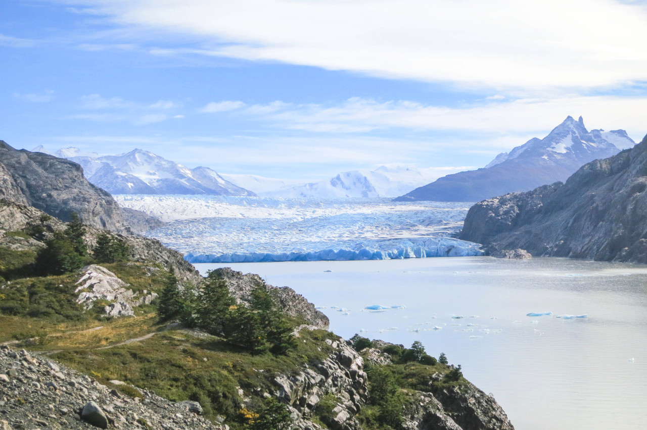 Grey Glacier, Torres del Paine National Park
Climate Map
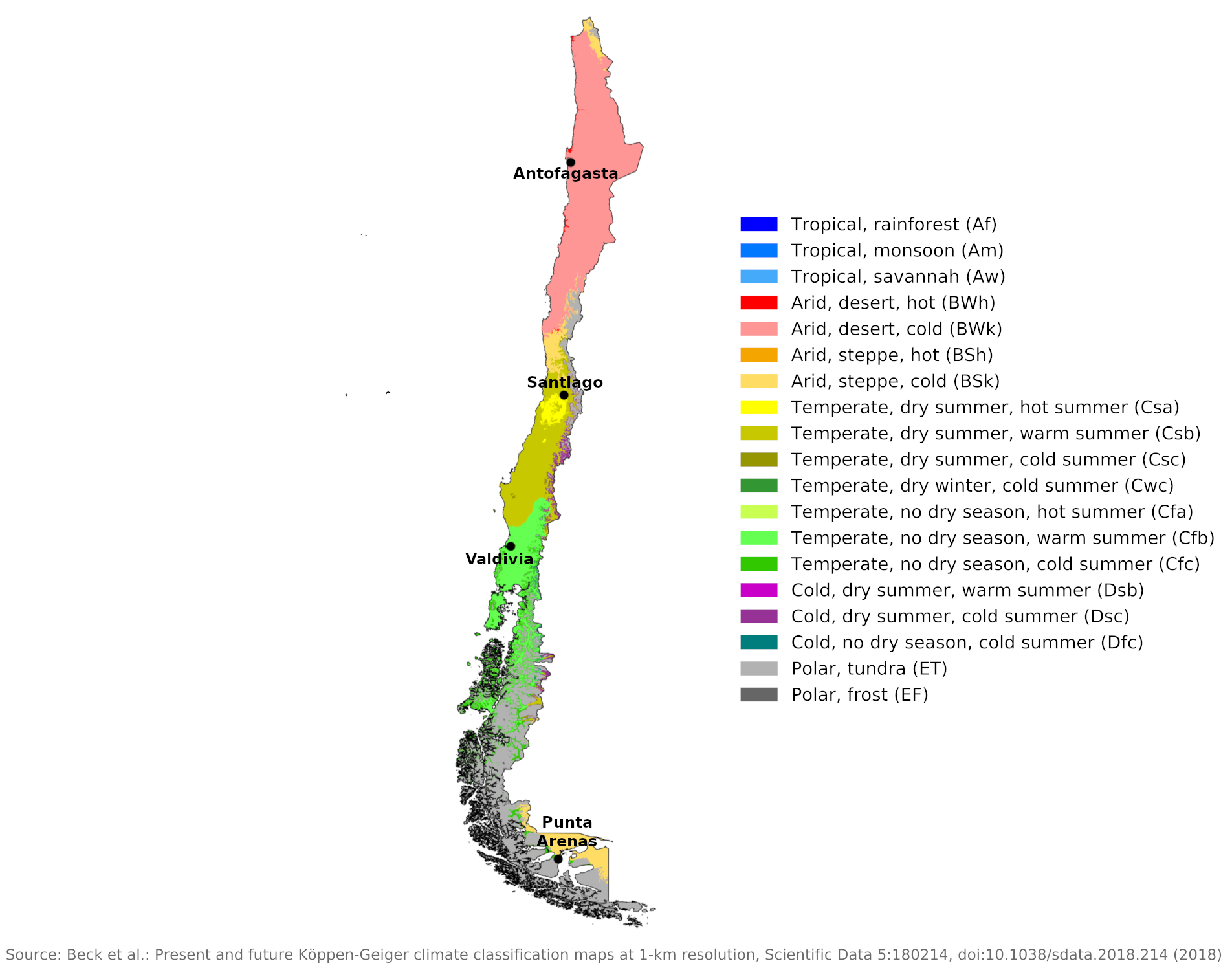 Climate map of Chile
What is the climate of Chile like?
Chile stretches 4,200 km (2,600 mi) north to south along the Pacific coast of South America, but has an average width of only 160 to 320 km (100 to 200 mi). Its eastern border with Bolivia and Argentina follows the ridge line of the main Andes mountain range, so that the eastern part of this narrow country is very mountainous, with the higher parts rising to over 5,000 meters (16,000 feet). South of Santiago the mountains are lower and more rugged, but the country is rugged with hundreds of small islands off the coast from Puerto Montt to Tierra del Fuego.
A large part of Chile therefore has a mountain climate with permanent snow and glaciers in the higher elevations. The height of the snow line gradually decreases from north to south with decreasing temperature and increasing precipitation. There is little rainfall in the mountains of northern Chile, so the snow line is high.
Most people live in the lowlands of central Chile between Valparaíso and Valdivia. The climate varies greatly, from tropical heat and extreme drought on the north coast to low temperatures and extreme humidity in western Tierra del Fuego and on the south coast. In general it can be said that the temperature extremes are not as great as in corresponding latitudes in the northern hemisphere because the long expanse of coastal waters produce cooler summers and the warmer winters. The cold Antarctic or Humboldt Current flows north along the coast, significantly altering the heat of the arid, tropical plateaus.
Northern Chile
The lowlands of Northern Chile, from the border with Peru south to about Coquimbo at 30°S, is one of the driest regions in the world. The climate is strongly influenced by the high mountain barrier to the east, which drives the humid easterly winds off the Atlantic to such heights that they sweep across Chile without leaving a drop of rain. Light rain falls in the desert regions at very rare intervals, but this is brought by the prevailing coastal winds.
This is a typical "cold-water coastal desert" where, although virtually rainless, the weather is often cloudy and relatively cool for the latitude. Although warmed by a tropical sun during the day, it is cooled at night by the proximity of snowy heights and a cold ocean current. The coastal strip has a lot of fog and frequent light drizzle with rather little sunshine. The cloud usually disperses inland during the day in summer and temperatures are slightly higher here.
There is a small difference in temperature between summer and winter and the weather is remarkably consistent from day to day. Antofagasta illustrates the conditions in this coastal desert.
| Climate data for Antofagasta (1981–2010) | |||||||||||||
|---|---|---|---|---|---|---|---|---|---|---|---|---|---|
| Month | Jan | Feb | Mar | Apr | May | Jun | Jul | Aug | Sep | Oct | Nov | Dec | Year |
| Average high °C (°F) | 23.8 (74.8) | 23.8 (74.8) | 22.8 (73.0) | 20.7 (69.3) | 19.0 (66.2) | 17.4 (63.3) | 16.9 (62.4) | 17.0 (62.6) | 17.7 (63.9) | 18.9 (66.0) | 20.3 (68.5) | 22.2 (72.0) | 20.0 (68.0) |
| Daily mean °C (°F) | 20.2 (68.4) | 20.0 (68.0) | 19.1 (66.4) | 17.1 (62.8) | 15.5 (59.9) | 14.2 (57.6) | 13.7 (56.7) | 14.0 (57.2) | 14.7 (58.5) | 15.8 (60.4) | 17.3 (63.1) | 18.9 (66.0) | 16.7 (62.1) |
| Average low °C (°F) | 17.4 (63.3) | 17.1 (62.8) | 16.2 (61.2) | 14.5 (58.1) | 13.2 (55.8) | 12.1 (53.8) | 11.6 (52.9) | 12.1 (53.8) | 12.8 (55.0) | 13.9 (57.0) | 15.1 (59.2) | 16.2 (61.2) | 14.3 (57.7) |
| Average precipitation mm (inches) | 0.0 (0.0) | 0.0 (0.0) | 0.0 (0.0) | 0.1 (0.00) | 0.3 (0.01) | 0.8 (0.03) | 0.4 (0.02) | 0.4 (0.02) | 0.3 (0.01) | 0.0 (0.0) | 0.1 (0.00) | 0.1 (0.00) | 2.5 (0.10) |
| Source: Dirección Meteorológica de Chile | |||||||||||||
Central Chile
Central Chile, between about 32° and 38° S, has a Mediterranean climate. Summers are practically rainless and fairly warm, while the winter months from April to September are mild and moderately wet with changeable weather. The long dry season of this region necessitates irrigation and the vegetation has a subtropical appearance, with palm trees growing naturally up to 37° south.
Frost and snow occasionally occur inland but are rare on the coast. Daily hours of sunshine on the coast average between two and three in winter and eight or nine in summer. Inland, where there are fewer clouds, this increases to three to four in winter and nine to ten in summer. Santiago is typical of this central part of Chile.
| Climate data for Santiago (1981–2010) | |||||||||||||
|---|---|---|---|---|---|---|---|---|---|---|---|---|---|
| Month | Jan | Feb | Mar | Apr | May | Jun | Jul | Aug | Sep | Oct | Nov | Dec | Year |
| Average high °C (°F) | 30.1 (86.2) | 29.5 (85.1) | 27.4 (81.3) | 23.1 (73.6) | 18.5 (65.3) | 15.7 (60.3) | 15.3 (59.5) | 17.1 (62.8) | 19.5 (67.1) | 22.9 (73.2) | 26.1 (79.0) | 28.8 (83.8) | 22.8 (73.0) |
| Daily mean °C (°F) | 21.2 (70.2) | 20.3 (68.5) | 18.2 (64.8) | 14.4 (57.9) | 10.9 (51.6) | 9.0 (48.2) | 8.2 (46.8) | 9.8 (49.6) | 12.0 (53.6) | 15.0 (59.0) | 17.7 (63.9) | 20.1 (68.2) | 14.7 (58.5) |
| Average low °C (°F) | 13.3 (55.9) | 12.8 (55.0) | 11.4 (52.5) | 8.6 (47.5) | 6.4 (43.5) | 5.0 (41.0) | 3.9 (39.0) | 5.0 (41.0) | 6.7 (44.1) | 8.6 (47.5) | 10.3 (50.5) | 12.2 (54.0) | 8.7 (47.7) |
| Average precipitation mm (inches) | 0.6 (0.02) | 1.3 (0.05) | 6.1 (0.24) | 16.3 (0.64) | 55.5 (2.19) | 83.3 (3.28) | 75.9 (2.99) | 55.1 (2.17) | 27.2 (1.07) | 12.9 (0.51) | 6.2 (0.24) | 1.5 (0.06) | 341.8 (13.46) |
| Source: Dirección Meteorológica de Chile | |||||||||||||
Southern Chile
In Southern Chile, the climate undergoes a radical change from around 38°S—the prevailing winds arrive from the west, resulting in a long rainy season with phenomenal rainfall. The plains and western slopes of the Andes are covered with forests, the rivers become torrents and the sky is overcast with heavy clouds for much of the year.
Valdivia is representative of the north of this area, while Punta Arenas on the Strait of Magellan is representative of the extreme south of the country. Much of this area is very wet year-round with lots of cloud and often disrupted, changeable weather. Winter temperatures can be comparatively high. Frost is rare and snow doesn't last long. Annual rainfall is 2,500 to 5,000 millimeters (100 to 200 inches), much of which falls as snow on the higher mountains and further south. Winters are rarely very cold on the coast, but summers are cool and cloudy. The weather and climate here is very similar to that on the coasts of British Columbia, Alaska or Norway.
In the extreme south, a new climatic influence is encountered in the warm equatorial current flowing down the east coast of South America. Although the Andes are lower at these latitudes, they also exert a modifying influence on these areas, protecting them from the cold westerly storms and giving them a drier climate. Punta Arenas is characterized by very little annual rainfall as it is sheltered from the humid westerly winds by the southern Andes. The weather and climate here are similar to southern Argentina.
| Climate data for Valdivia (1981–2010) | |||||||||||||
|---|---|---|---|---|---|---|---|---|---|---|---|---|---|
| Month | Jan | Feb | Mar | Apr | May | Jun | Jul | Aug | Sep | Oct | Nov | Dec | Year |
| Average high °C (°F) | 23.5 (74.3) | 23.8 (74.8) | 21.1 (70.0) | 16.9 (62.4) | 13.3 (55.9) | 11.0 (51.8) | 10.7 (51.3) | 12.4 (54.3) | 14.7 (58.5) | 16.8 (62.2) | 19.0 (66.2) | 21.6 (70.9) | 17.1 (62.8) |
| Daily mean °C (°F) | 16.2 (61.2) | 16.2 (61.2) | 14.4 (57.9) | 11.6 (52.9) | 9.5 (49.1) | 8.0 (46.4) | 7.4 (45.3) | 8.2 (46.8) | 9.5 (49.1) | 11.2 (52.2) | 12.9 (55.2) | 15.0 (59.0) | 11.7 (53.1) |
| Average low °C (°F) | 8.8 (47.8) | 8.5 (47.3) | 7.7 (45.9) | 6.3 (43.3) | 5.7 (42.3) | 5.0 (41.0) | 4.0 (39.2) | 4.1 (39.4) | 4.3 (39.7) | 5.5 (41.9) | 6.9 (44.4) | 8.4 (47.1) | 6.3 (43.3) |
| Average precipitation mm (inches) | 49.8 (1.96) | 38.6 (1.52) | 69.6 (2.74) | 131.8 (5.19) | 256.0 (10.08) | 336.0 (13.23) | 261.7 (10.30) | 226.5 (8.92) | 130.0 (5.12) | 109.1 (4.30) | 84.0 (3.31) | 59.8 (2.35) | 1,752.9 (69.01) |
| Source: Dirección Meteorológica de Chile | |||||||||||||
| Climate data for Punta Arenas (1981–2010) | |||||||||||||
|---|---|---|---|---|---|---|---|---|---|---|---|---|---|
| Month | Jan | Feb | Mar | Apr | May | Jun | Jul | Aug | Sep | Oct | Nov | Dec | Year |
| Average high °C (°F) | 15.2 (59.4) | 14.7 (58.5) | 12.8 (55.0) | 10.0 (50.0) | 6.7 (44.1) | 4.1 (39.4) | 4.1 (39.4) | 5.6 (42.1) | 8.3 (46.9) | 10.8 (51.4) | 12.8 (55.0) | 14.3 (57.7) | 10.0 (50.0) |
| Daily mean °C (°F) | 10.8 (51.4) | 10.3 (50.5) | 8.5 (47.3) | 6.2 (43.2) | 3.7 (38.7) | 1.5 (34.7) | 1.4 (34.5) | 2.3 (36.1) | 4.2 (39.6) | 6.4 (43.5) | 8.4 (47.1) | 9.9 (49.8) | 6.1 (43.0) |
| Average low °C (°F) | 6.9 (44.4) | 6.6 (43.9) | 5.2 (41.4) | 3.5 (38.3) | 1.5 (34.7) | −0.7 (30.7) | −0.9 (30.4) | 0.0 (32.0) | 1.3 (34.3) | 2.7 (36.9) | 4.5 (40.1) | 5.9 (42.6) | 3.0 (37.4) |
| Average precipitation mm (inches) | 42.4 (1.67) | 30.7 (1.21) | 42.2 (1.66) | 44.7 (1.76) | 40.8 (1.61) | 29.4 (1.16) | 30.4 (1.20) | 32.1 (1.26) | 27.1 (1.07) | 28.8 (1.13) | 28.0 (1.10) | 31.6 (1.24) | 408.2 (16.07) |
| Source: Dirección Meteorológica de Chile | |||||||||||||
References
- E. A. Pearce, Charles Gordon Smith, (1990) The Hutchinson World Weather Guide, John Murray Press. ISBN 1859863426
- Timothy L. Gall, (ed.), (2003), Worldmark Encyclopedia of the Nations, Eleventh Edition, Thomson Gale
- Hugh Chisholm, (ed.), (1911), Encyclopædia Britannica, Eleventh edition, Cambridge University Press
The Climate of
Chile
In summary:
In general, Chile is divided into three climatic regions: (1) The north, which contains the Atacama Desert, one of the driest regions in the world. (2) The middle, has a Mediterranean climate, with mild, wet winters, and long, dry summers. (3) The south, a region of mountains and fjords, has high winds and heavy rains.
Annual rainfall ranges from no recorded precipitation in some parts of the north to 500–1000 mm (20–40 in) around Concepción, in south-central Chile, to more than 4000 mm (160 in) in some southern regions.